
Maps & Atlases
by Carl Franz
[Carl’s note: This article updates and expands the Maps & Sources section of the 13th Edition of The People’s Guide To Mexico. A special thanks to Mark Walker of MexicoMaps.com for his excellent suggestions.]
Road Maps and Driving Atlases
Opening a fresh road map and spreading it out on the kitchen table are among the many pleasures of planning a trip to Mexico. So many highways, trails and tempting side roads... yet so little time. Maps are a vital tool for both daydreaming and actual planning but until recently, getting your hands on a decent road map or atlas of Mexico before you left home was no small challenge. Even today, don't expect to find road maps in Mexican gas stations -- or even in Mexican book stores. Ironically, it is now much easier to buy good maps of Mexico before you leave home.
Road maps may or may not be available at Mexican Consulate and National Tourism offices outside of Mexico. As you reach the border, however, you’ll usually (but again, not always) find maps on the US side at gas stations, tourist agencies, large hotels, and insurance office. Get two copies; you'll lose or loan one map almost immediately.
As you can see, getting your hands on a good map is still somewhat hit-or-miss. Because of this, I definitely recommend that you buy at least one decent map or atlas from a dealer before you leave home. Deciding which road map or atlas to purchase isn't that difficult, mainly because you have only a few choices. If you're like us, you'll probably want more than one, as every map has its particular strengths and weaknesses. Let's start by briefly reviewing which maps and atlases are out of print and very difficult to locate, and then we’ll look closely at the maps which are readily available.
Out-of-print: Single sheet tourist road maps in the Carta Azul, Patria and Carta Turistica series are all ancient history. Sadly, the excellent Pemex Road Atlas and compact, wire-bound Pronto Road Atlas have suffered the same fate. If you collect maps, count yourself lucky to stumble across any of these. Needless to say, we guard our own copies jealously.
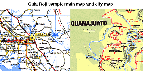
Guia Roji: 
Now available in the U.S. and Canada, this leading map publisher offers several road atlases and a long list of single sheet maps, as well as extremely detailed CD ROM collections (PC only, unfortunately). Guia Roji maps are very well-researched and highly reliable. Although I once described their single sheet maps as "notoriously difficult to read", this is not true of Guia Roji's more recent driving atlases and excellent tourist maps. (By the way, most gringos undertandably call these maps Guia Roja (Red Guide). The map covers are definitely rojo, but Guia Roji takes its name from its illustrious founder, Señor Roji.)
Mexico Tourist Road Atlas, Guia Roji, 2006, $32.95, 216 pages, 8-5/8" x 11", Scale 1:1,000,000.
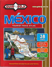 This very attractive driving atlas is designed for travelers from the US and Canada. It has updated mapping nearly identical to the Mexico Road Atlas, or "Por las Carreteras de Mexico", the most up-to-date road atlas of Mexico. Features include index of cities and towns, index of protected areas, 51 city plans, 45 highway route plans with gas/food/lodging/etc., mileage chart, distance/travel times map, railroads map, airports map.
The 70 page tourist guide section is in English, with color photographs. The wording on all of Guia Roji's maps is in Spanish, though this isn’t a problem as town names and map symbols are the same in either language. The distances are in kilometers, as are the road signs in Mexico.
The tourist info includes routes covered by Mexico's Green Angels, temperature and precipitation charts, and a detailed Distances Table. These include toll booths, gas stations, highway numbers, intersections, bridges, airports, etc. This is all good stuff, but the dense format and miniscule text require 20/20 vision or a magnifying glass.
Por Las Carreteras de Mexico: Guia Roji, (Updated yearly), $26.95,8 1/2 x 11 inches. Scale 1:1,000,000
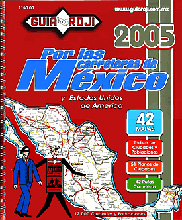 The original, Spanish language edition of the Guia Roji Road Atlas (discussed above) is the most up-to-date Mexico road atlas by the most authoritative map publishers in Mexico. Highway route plans indicate toll booths and toll fees, possible side trips and distances, places to stay and places to eat, gas stations, auto mechanics, medical services. Identifies location of traffic hazard signs and intersections with numbered highways. Also locates commercial districts, panoramic and scenic views, rest areas, public telephones, border crossings.
This map is a few dollars less, but lacks the tourist information . To further complicate your decision, the maps in the Spanish atlas are identical in content to the English version, but have a noticeable edge in overall readability -- the colors are more vivid in the Spanish atlas and the contrast is sharper. I didn't say this would be easy....
Mini Atlas de Carreteras: Guia Roji. A very slim road atlas with poor readability. Not recommended.
Gran Atlas de Carreteras: Guia Roji, 1998, 17 x 22 inches, 80 pages. This very large atlas features 31 states and the Federal District. The maps are vintage Guia Roji: richly detailed, but with tiny, difficult to read text. Serious map addicts will want this tabloid-sized atlas anyway.
Errors: Even the best maps have mistakes and omissions, and though Guia Roji's are very good, they aren't perfect. The most glaring goof on their road maps was the (for many years, non-existant) four lane highway shown between Mazatlan and Escuinapa de Hidalgo. This coastal highway was long on Mexico's wish and, fortunately, it has recently been completed.
Guia Roji Web site: As of this writing their website is quite new and still incomplete, but I expect it will improve soon. Gobernador José Morán No. 31, Col. San Miguel Chapultepec,11850 México, D.F. Phones: 515 0384 515-7963 271-8699; Fax: 277-2307. Information by email: sugerencias@guiaroji.com.mx; map sales by email:
ventas@guiaroji.com.mx; website: <http://www.guiaroji.com.mx>
Our recommendation
If you're looking for a Mexican road atlas, Guia Roji is clearly your best choice. The 8.5 x 11 inch size might seem burdensome if you're traveling by public transportation, but the combination of good detail and readability is well worth a few extra ounces. If size is very important to you, I'd buy the less expensive Spanish edition. Use a good razor knife to slim the atlas down. Bind the most needed pages together at Kinko's or do-it-yourself with duct tape. You're on your way!

|
Maps of Mexico Index Map Dealers & Sources Road Maps and Driving Atlases Single Sheet Road Maps of Mexico State & City Maps |
|
Homepage
|
|||||||||||||||||
|
|||||||||||||||||