Copper Canyon Home Page
Another View
Mexico's Copper Canyon:
Part 1B
by Carl Franz
Cusarare and the Sierra Madre Highlands
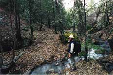 Early Jesuit missionary-explorers aptly described the Sierra Madre's cooler highland region as the "High Tarahumara". In sharp contrast to the dramatic "big ditches" of the main barrancas, the mountainous highlands are a complex jigsaw puzzle of tributary canyons, mesas, shallow valleys and interlocking ridges.
To confuse the trail system even more, crude logging and mining roads have been cut almost at random throughout the country. When you cross these with the ancient network of Tarahumara footpaths and grazing trails that link their widely separated cabins and cave dwellings with outlying granaries, croplands, woodlots, waterholes and pastures, you have an orienteer's nightmare. It is an especially confusing topography for hikers and I seldom entered it without getting lost for at least a few hours.
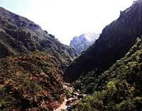
Barranca Country
I liked to tell hikers in Batopilas that they could forget about using a compass. "There are just three cardinal points in this barranca: upstream, downstream, and "straight up'". At a depth of well over a mile and tightly enclosed by near-vertical rock walls, I also classified most of our hikes in the canyon as either "steep, very steep, or ridiculously steep".
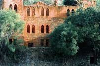
 In addition to chronic charley horses and over-developed calf muscles, exploring the Batopilas Canyon gave me a tremendous interest in the region's mining era and its legendary bonanzas of gold and silver. As a hiker, I was especially intrigued by the still-visible remains of the camino real network. For almost three centuries, convoys of mules laden with silver and gold bullion had trudged out of these canyons on highly improved trails known as "royal roads". With more than one thousand registered mines, Batopilas had itself produced over a billion ounces of pure silver. There were so many muleskinners competing for space that early Spanish authorities began to enforce strict traffic laws on pack trains to reduce gridlock and trail rage.
In studying old mining histories, I discovered that the principal treasure trails included a series of well-stocked rest areas for the mules and their crews. Each "estacion" or station provided shelter, fodder, meals and additional security for the pack train. Since a large "conducta" would have as many as one hundred mules, plus a large crew of wranglers and guards, it stood to reason that these stations must have included numerous buildings and corrals. Thanks to a tip from a former muleskinner, I'd visited the remains of a station near the present highway to Batopilas. But... what about all the others that were still out there, abandoned when the old mines had closed? Could these long forgotten stations be located again? If so, what is their present condition?
 When several old miners in Batopilas confirmed that the last conductas had traveled over the camino real as recently as the 1920's, I began to weave my various investigative threads into the fabric of a Great Idea. Wouldn't it be a great adventure to retrace these old Spanish mining trails, and to create a map as a means of preserving their memory? Assuming it could be done, what else might be discovered along the way? Spanish colonial mining artifacts? Cliff dwellings and Tarahumara rock art? Perhaps even Pancho Villa's long-lost treasure?
These were tempting daydreams, but before I got in over my head, my plan had
 |
|||
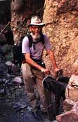
Carl works mining bellows |
|||
To add to the challenge, the full camino real network extended many hundreds, if not thousands of miles. Some segments were redundant, others were quite long. Should I start by heading west, on the early 18th century route to the Pacific coast, or would it be safer to take the 19th century trails, east toward Chihuahua? I'd been warned that some of the western trails now pass through the fiefdoms of irritable, paranoid "narcos". Assuming I wasn't picked off as a drug agent or rival smuggler, it could literally take years to cover so much ground.
Feeling somewhat overwhelmed, I returned to my panel of grizzled old-timers for a much-needed sanity check and second opinion. Considering that prospectors are also professional optomists, I shouldn't have doubted the outcome. When I gingerly raised the possibility of exploring the "royal roads", their response was a unanimous and enthusiastic, "¡Por supuesto! Why not? When do we leave?"
Would you like to read more about hiking and exploring the Copper Canyon? Stay tuned.... I'll continue adding to this series just as soon as I can. --- Carl Franz
 |
|||
Order
|
|||
Support The People's Guide to Mexico. Click the frog - Donate! |
||
Homepage
|
|||||||||||||||||
|
|||||||||||||||||